Tilghman Island Marina - 410-886-2500 |
|
Directions to Tilghman Island Marina by Land & Sea |
|
| Tilghman Island Marina is located
at the northwest corner of Tilghman Island, overlooking the Chesapeake Bay, the west entry to Knapps Narrows Channel
and Back Creek. From our boat docks you can see the water trails, Poplar Island and Chesapeake Bay's Western Shore,
about 12 miles west of Tilghman. GPS Position N38 43.11, W76 20.18 |
|
|
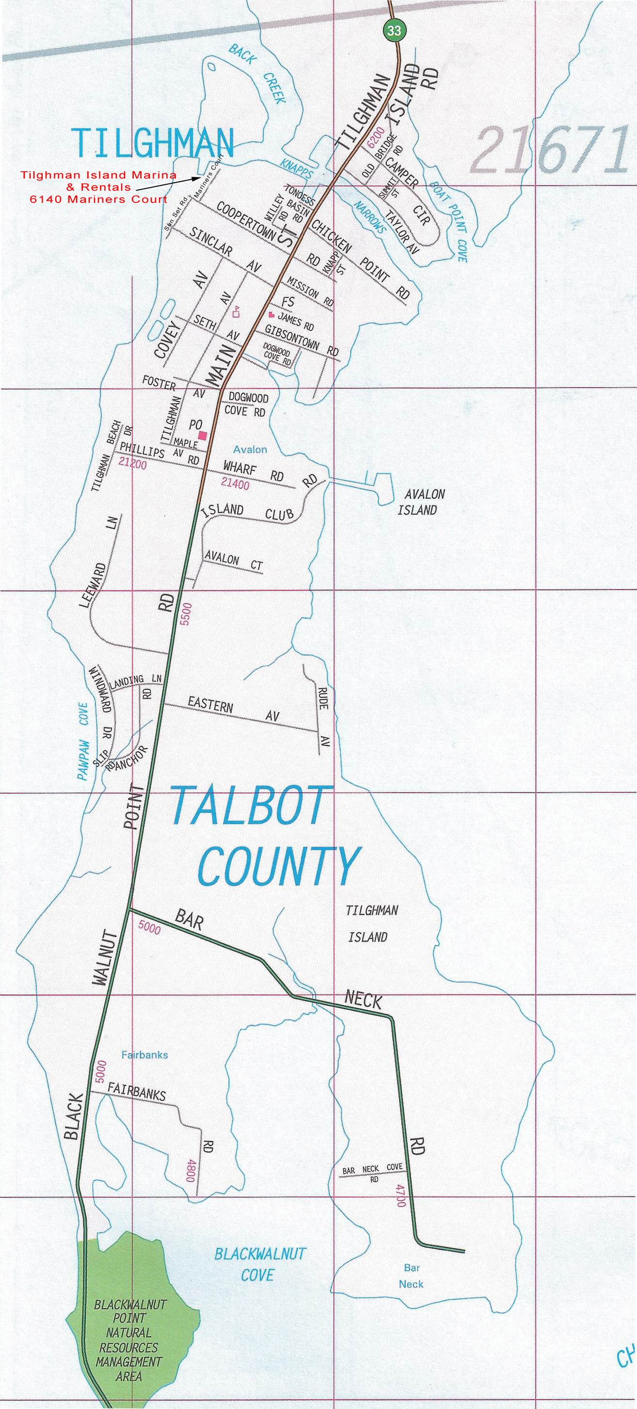
Tilghman Island Street Map |
Directions By Land - Here for Google Map
|
Directions By Sea - Here for Tilghman Island Marina's Location on Chart 12263 PDF |
|
|
Coming from North Chesapeake Bay |
From Bay Main Shipping Channel - Fl
G "83" Once at Fl G "83", follow a course of 123°m for 4.9nm. This brings you to Fl G "1W", the west entry mark to Knapps Narrows. Leave it to your port side while heading for G "3" directly in front. Continue past G "3" leaving it to port and then past floating buoy R "4" leaving it to starboard. Then steer towards G "5" leaving it to port. Favor the starboard (southern) shore for deeper water as you enter the Knapps Narrows Channel. The shoreline is defined by riprap stone and the yards of upscale homes which surround the marina's basin. Just after passing the riprap stone you will see our 1st marina pierhead and then the basin entry on the right. Note: Knapps Narrows Channel marks on west side have been changing just about every year so be sure to reference the most recent chart. |
|
Coming from South Chesapeake Bay |
From Bay Main Shipping Channel - Fl
R "82" Once at Fl R "82", follow a course of 80°m for 4nm. This brings you to Fl G "1W", the west entry mark to Knapps Narrows. Leave it to your port side while heading for G "3" directly in front. Continue past G "3" leaving it to port and then past floating buoy R "4" leaving it to starboard. Then steer towards G "5" leaving it to port. Favor the starboard (southern) shore for deeper water as you enter the Knapps Narrows Channel. The shoreline is defined by riprap stone and the yards of upscale homes which surround the marina's basin. Just after passing the riprap stone you will see our 1st marina pierhead and then the basin entry on the right. Note: Knapps Narrows Channel marks on west side have been changing just about every year so be sure to reference the most recent chart. |
|
Coming from Eastern Bay |
From Tilghman Point - Fl R "4" Once at Fl R "4", follow a course of 241°m for 6nm to R "2". (Along this course line you'll pass by G "3" and Fl R "2A" .) Once at R "2", change course to 10°m for 5.4nm to Fl G "1W" which marks the west entry to Knapps Narrows. (Along this course line you'll pass by R "8", R "6", G "5", R "4" and G "3".) This brings you to Fl G "1W", the west entry mark to Knapps Narrows. Leave it to your port side while heading for G "3" directly in front. Continue past G "3" leaving it to port and then past floating buoy R "4" leaving it to starboard. Then steer towards G "5" leaving it to port. Favor the starboard (southern) shore for deeper water as you enter the Knapps Narrows Channel. The shoreline is defined by riprap stone and the yards of upscale homes which surround the marina's basin. Just after passing the riprap stone you will see our 1st marina pierhead and then the basin entry on the right. Note: Knapps Narrows Channel marks on west side have been changing just about every year so be sure to reference the most recent chart. |
|
Coming from Choptank River |
Coming from Oxford, Tread Avon River
& Choptank River Light From Choptank River Light, follow a course of 309°m for 7.4nm to Fl G "3E". Once at Fl G "3E", head towards G "5" and finally Fl R "6" which brings you into the Knapps Narrows Channel east side. Follow makers on this side leaving green to port and red to starboard. Upon entering the Knapps Narrows Channel, you can contact the draw bridge operator on radio channel 13 to request an opening if necessary. Go under the bridge and follow the Narrows to the west end. Take note that once you go under the bridge, all green markers are passed to the starboard side and red markers to the port side. We are the last marina on the left, just prior to exiting into the Chesapeake Bay. Note: Knapps Narrows Channel marks can change so be sure to reference the most recent chart. |
|
Call 410-886-2500 for Pricing and Reservations 6140 Mariners Court, Tilghman Island, MD 21671 - www.TilghmanMarina.com |
|